Távérzékelési technológiák és térinformatika online, a szolgáltatók és felhasználók online folyóirata
Megjelenik évente két alkalommal
ISSN 2062-8617
Főszerkesztő:
Bakó Gábor
Szerkesztők:
Bartha Csaba
Gruber Anita
Kardeván Péter
Lelleiné Kovács Eszter
Licskó Béla
Nagy János
Szerdahelyi Tibor
Zentai László
Szerkesztőség:
1117 Budapest, Pázmány Péter sétány 1/A
Postacím: 2314 Halásztelek II. Rákóczi Ferenc út 42.
Telefon:
06 70 615 7223
e-mail:
Hirdetésszervezés:
Gruber Anita
+36-30-342-45-69
További munkatársak:
Mészáros János
Molnár Zsolt
Design:
Göttinger Erika
T-Futaki Csenge
![]()
Az adat keletkezésétől a felhasználásig
Archaeological Remote Sensing Survey - Lidar, Hyperspectral and Aerial imaging in one campaign
RS&GIS - 2011 / 2. Gergely Padányi-Gulyás ( gergely.padanyi@mnm-nok.gov.hu) – Máté Stibrányi ( mate.stibranyi@mnm-nok.gov.hu)
ABSTRACT:
The focus of this paper is an EUFAR remote sensing archaeological project in Hungary called ARMSRACE. Although the project is still in progress and there are no tangible results yet, it still seems to be a good idea to share information about the novel data acquisition scheme combining high-resolution digital imaging, hyperspectral and LiDAR sensors simultaneously over such extended areas. The data were collected in August 2010 and delivered after pre-processing in February 2011. The main goal of this paper is to present the essence of this archaeological remote sensing survey and also give a picture about EUFAR Transnational Access.
Keywords: remote sensing, LiDAR, hyperspectral imaging, aerial photogrammetry, archaeological predictive modeling, historical climate changes.
ÖSSZEFOGLALÁS:
Jelen cikk célja egy régészeti célú távérzékelési EUFAR pályázat, az ARMSRACE rövid ismertetése. A pályázat keretein belül egy meglehetősen nagy, 60x10 km-es terület került felmérésre egyidőben lézerszkennerrel, hiperspektrális és digitális kamerával, mely mind technológiájában, mind méreteiben példa nélküli a hazai régészetben. A repülésre 2010 augusztusában került sor, az előfeldolgozott adatok 2011 februárjában érkeztek meg. Az adatfeldolgozás jelenleg még kezdeti stádiumban van, ennek ellenére egy első tájékoztatást mindenképpen érdemes adni, melynek során a pályázat ismertetésén túl az EUFAR Transnational Access is bemutatásra kerül.
Kulcsszavak: távérzékelés, LiDAR, hiperspektrális képalkotás, légifotogrammetria, régészeti célú prediktív modellezés, történelmi klímaváltozások.
Introduction
In August, 2010 a British aeroplane loaded with remote sensing equipment took off several times from Sárrét Airport, Hungary. Its single aim was to simultaneously collect as much data as possible for two Hungarian projects called AIMWETLAB and ARMSRACE. The aeroplane was equipped with a Leica LiDAR, a Leica 39 megapixel digital camera and an AISA Dual hyperspectral scanner. The data collecting method was the same, but the purposes of the two projects were quite different. AIMWETLAB (Aerial Imaging of the Wetlands of Lake Balaton and the Kis-Balaton)[1] was designed to get high resolution data for survey of shore vegetation, while ARMSRACE (Archaeological and Relief Modeling of the Sárvíz-valley for Reconstruction of Ancient Climate Events) intended to use the data for searching of new archaeological sites and modeling climate changes throughout history. This paper is dedicated to the latter one, ARMSRACE[2]. The whole application was funded by EUFAR (European Facility for Airborne Research) Transnational Access.
The main goal of this research was to connect archaeological settlement patterns with historic geomorphological and hidrological modelling based on remote sensing data. GIS-based investigation of settlement patterns with elevation models are very rare in Hungary, most of it completed in the eastern part of the country. Our goal was to collect archaeological and topographical data from a pilot area and to build geomorphologic and hydrologic models based on these datasets, and to use these models to investigate the effect of climate changes on historic settlements through archaeological sites. Remote sensing data will be closely integrated into past and future fieldwork.
So far archaeological settlement pattern research and interpretation was only possible based on wide-scale measurements and reconstructions. In Transdanubia, environmental reconstructions were previously based on borehole datasets since no other surveys were carried out. Geoinformation systems and remote sensing allow reconstructions at a much larger scale. The occurance of several significant historic changes of climate is a known fact, but the impacts of these on the settlements is yet unknown, although these are essential for understanding the changes of settlement pattern. The central region of the Carpathian Basin is a floodplain which was especially affected by changes of climate. The topography and the already accumulated archaeologic data of this area is ideal for such a study.
1. EUFAR TRANSNATIONAL ACCESS
The survey was completed by the Airborne Research and Survey Facility (ARSF) of the Natural Environmental Research Council (NERC) of the UK, based at Staverton Airport, Gloucester. According to their homepage, „EUFAR is an ‘Integrating Activity’ funded by the European Commission under FP5/FP6/FP7. EUFAR aims to coordinate the operation of instrumented aircraft and hyperspectral imaging sensors, exploiting the skills of experts in airborne measurements in the fields of environmental and geo-sciences, in order to provide researchers with the infrastructure best suited to their needs.”[3] The Transnational Access (TA) Activities has a budget of 3M€ and offers 6 instruments and 22 instrumented aircrafts, including scientific and engineering support for integration of instruments, planning of airborne campaigns, and data analysis. The most important thing about EUFAR TA is that fully funded flight hours can be applied with a good application after a successful selection procedure on a chosen aeroplane equipped with up-to-date remote sensing instruments.
2. EQUIPMENT AND DATA COLLECTION[4]
The aircraft for both Hungarian projects was a Dornier 228 aircraft operated by NERC-ARSF and the flight window was chosen to be between 16 and 26 August 2010. The aircraft and crew were stationed at Sármellék airport, a former military air base now serving international flight traffic, located in the immediate vicinity of Lake Balaton, therefore close to both of the survey areas of AIMWETLAB and ARMSRACE. This proved to be ideal for logistics as the flight time was shared between the projects, so days of acceptable weather could be exploited beyond the flight endurance of the plane. In many cases, after taking off in the morning and completing a five-hour flight, the aircraft would land for a quick refueling (facilitated by the sparse traffic at the airport) and be back on the study site to continue the survey in the afternoon. The chosen aircraft was equipped with a Leica ALS 50-II LiDAR, a Leica RCD-105 39 megapixel digital camera and a Specim Eagle&Hawk (AISA DUAL) hyperspectral scanner.
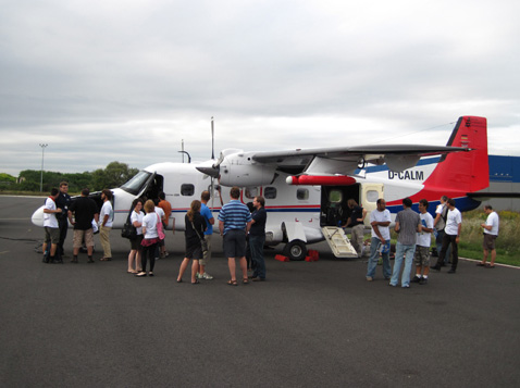
Fig. 1 The Dornier 228 aircraft at Sármellék airport
AISA Eagle is a relatively compact imaging spectrometer with a spectral range of 400-970 nm in the visible and near infrared light spectrum with a maximum spectral resolution of 3.3 nm (subject to spectral binning in marginal light conditions) and 244 bands. The view angle range of the instrument is 37°. AISA Hawk is an imaging spectrometer operating in the infrared and short wave infrared wavelengths with a range on 960 to 2450 nm and a spectral resolution of 6 nm adding up to 254 bands. The two imaging spectrometers are integrated to form a dual imaging system collecting pixels through the same pushbroom configuration. The view angle range of this sensor is 24°.
Leica ALS50 is a compact topographic laser scanning system operating in the nearinfrared wavelength at a pulse frequency of up to 83 kHz. Multiple pulse capability allows for the exploitation of the pulse frequency at higher flight elevations. The instrument scans with a vibrating mirror, creating a sinusoidal point layout along the flight track. A maximum of four returns can be distinguished for each pulse.
The Leica RCD 105 camera is a medium-format digital imaging system designed to complement the ALS50 LiDAR. It has a 39 megapixel CCD and was designed to collect true colour images.
3. THE STUDY AREA
The study area is the valley of the Sárvíz River in County Fejér in Central Hungary (see Fig. 2). Sárvíz is an altogether 100 km long river which connects the Sárrét wetland with the river Sió and the Danube river. Its western bank is the loess ridge of Káloz-Igar, moderately hilly, but its eastern part is a flat region, the westernmost part of the Great Hungarian Plain called the Mezőföld. In this project we are focusing only on the northern part of the Mezőföld region. It’s approximate length is 60 km. On the flat eastern part even small changes of water level cause large shifts in the bank of the wetlands and the settlements, which use the nearest suitable areas for the water level to follow these changes. It is necessary because the loess bedrock of the region is highly permeable to water and wells could not reach the low-lying water table.
This area always has been a very important communication channel and thus was quite densely populated in the past 8000 years, including the town of Gorsium from the Roman Age, which was one of the largest settlements of its time and is part of the study area. As a major communication and commercial route from the NW of Europe to the eastern Mediterranean since the prehistory, this area usually had been more densely populated compared to its surroundings. The dense settlement structure, the low topography and the constraint that only surface waters (due to the loessy environment) were available can be an excellent indicator for reconstructing hydrology and climate.
The marshland area was drained in the 19th century, so all areas that were submerged up to the Early Modern Age can be studied in the field. The southern end of the area is one of the three pilot areas of the proposed Hungarian Landscape Value Cataster, the archaeological survey, which was performed by the National Heritage Center in 2010 (at that time it was called Field Service for Culturage Heritage in Hungary).
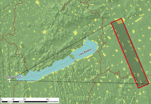
Fig. 2 Study area and flight plan
4. BENEFITS OF REMOTE SENSING DATA IN ARCHAEOLOGY
Amongst the datasets, the LiDAR was the most important for us. With LiDAR data we can create the actual digital elevation model (DEM) of the Sárvíz valley, which is essential for the water level reconstruction and relief modeling. By examining a hillshade image of the DEM (raster or TIN model) even the slightest slope anomalies become visible. Combining this with slope and aspect images together with vector data (rivers, roads etc.) we can find preferred sites for historic settlements. The terrain from the LiDAR will be the base for modeling the waterline.
Hyperspectral images are excellent for examination of soil types and vegetation. With a relatively good resolution the anomalies are also visible, which can show added information (extra iron content, buried buildings, disturbed soils etc). With the accurate vegetation map we can conclude the potential vegetation of the Sárvíz valley. The advantages of hyperspectral images are not well known and used in landscape-scale archaeology, and this project will contribute to providing further knowledge on this topic. After the atmospheric correction we can select the right images from the data cube for further analysis and can make classifications. Unfortunately there was no possibility to gather reference spectra during the campaign, but since our main goal with the hyperspectral data is to find relative anomalies it still can be done without reference data.
Because of the good resolution, aerial images are best for fieldwork. It is essential to rectify the images. Because of the high resolution they are also good for finding anomalies which cannot be seen on the LiDAR or the hyperspectral images (for example certain visible colouring on the fields, cropmarks etc).
5. PRE-PROCESSING AT ARSF-DAN
At ARSF-DAN (Data Analysis Node, based in the Remote Sensing Group at Plymouth Marine Laboratory, PML) in January 2011 both one of the authors of this paper and Andras Zlinszky (lead scientist of project AIMWETLAB) have had the opportunity to get a picture about the pre-processing. Hyperspectral data cubes are pre-processed to the level of radiance, and the orientation and position information are also supplied along with the data. Timing errors which would lead to minor positioning errors are also corrected by the DAN on a strip-by-strip basis. LiDAR data are also pre-processed by the ARSF-DAN to link recorded signal travel times and intensities to the position and altitude data of GPS and the IMU and the corresponding angle of the scanning mirror. A basic filtering is applied to flag points that most probably result from atmospheric or secondary echoes. To correct some minor errors in the scanning angle calibration, a roll correction is applied to each flight line, based on minimizing errors of fit in the overlapping parts of the strips. Aerial photogrammetric images can be georeferenced automatically based on positions provided from GPS and angles from IMU data which are also supplied by the pre-processing team.
6. PRELIMINARY RESULTS
As mentioned before, there are no tangible results yet. However, we already begun working with the LiDAR data, since relief modeling is the most important at the moment. Up to now we have tested several pieces of software to create an accurate and acceptable DTM. First of all, we tried the open source GRASS GIS with implemented LiDAR functions. It has not produced any satisfactory results yet: although it managed to filter out buildings, the dense vegetation (mainly forests) is still visible on the final DTM. ArcGIS free extension Felis Analyst is also a LiDAR tool which works with the last returns and seems to produce better DTM than GRASS GIS. Fig. 3 and Fig. 4 indicates the DSM from the first returns and the best of DTM yet from the last returns. Other software products are going to be tested like OPALS, TreesVis and Fusion. The conclusions so far: the main problem with the LiDAR data is that the point density is relatively low (0.5 points/m2) which causes only a small difference between the first and the last returns.
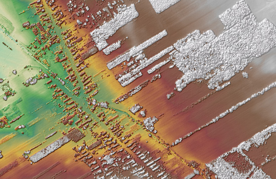
Fig. 3 DSM generated from the first returns using ArcGIS Felis Analyst
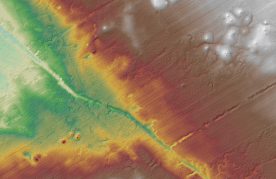
Fig. 4 DTM generated from the last returns using ArcGIS Felis Analyst
Fig. 5 indicates the LiDAR intensity data. Although it seems to be a good method to classify the different materials using intensity values such as forests, roads etc. which would help us in the DTM creation, it will not be possible, since at ARSF-DAN the intensity data were normalized between 0 and 255 instead of using true values, and therefore it is not advised to use them for scientific purposes.
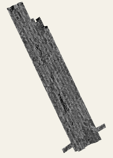
Fig. 5 LiDAR intensity data
7. ACKNOWLEDGEMENTS
The research leading to this paper has received fundings from the European Community's 7th Framework Programme (FP7/2008-20012). The support of the EUFAR team during the preparation, completion and aftermath of the survey is gratefully acknowledged. I would also like to thank NERC ARSF for their cooperation during the flight and ARSF-DAN for giving the opportunity to visit PML and get a picture about the pre-processing.
REFERENCES
[1] Lead scientist: András Zlinszky, junior research fellow at Balaton Limnological research Institute of the Hungarian Academy of Sciences
[2] For further information about project AIMWETLAB visit http://studiacrescent.com/abstracts/issue-nr.-11-(1-2011)/andras-zlinszky-et-colab.,-initial-report-of-the-aimwetlab-project
[3] For further information visit http://www.eufar.net
[4] Based on AIMWETLAB’s initial report